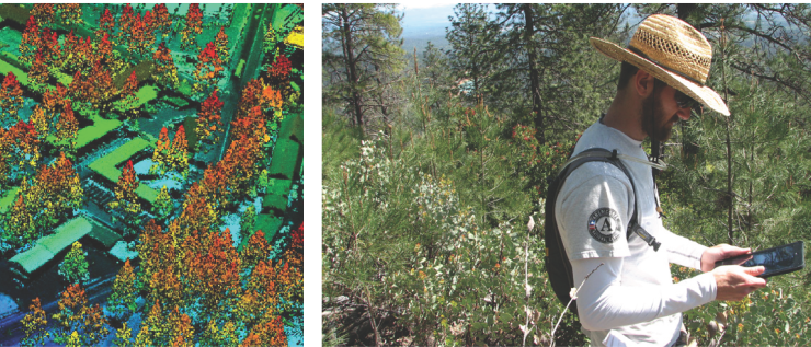
The Associate of Science degree in Geographic Information Systems (GIS) provides students with skills, knowledge and experience in the application of GIS. Students complete courses in the technical aspects of GIS and information technologies, along with courses in fields to which GIS is commonly applied, including geography, earth and social sciences, natural resources and engineering. Students gain knowledge of maps, geographic data, and imagery, while developing skills in data collection, analysis and map creation. As students progress through the program the applied field courses provide direction for learning about the application of GIS, which gives direction to GIS project work. Worksite learning allows students to gain GIS workplace experience in their chosen field and to develop contacts among the community of GIS professionals. Successful students will have strong computer and critical thinking skills. Refer to http://www.shastacollege.edu/gis for more information.
This degree is approved through the California Community College Chancellor’s Office. Upon satisfactory completion of all degree requirements and filing an application for graduation with Admissions and Records, the student’s transcript will reflect completion of this degree.
Program Outcomes:
Explain and summarize key GIS concepts, applications and societal implications. Perform GIS data acquisition, capture, editing, and attributing.
Manage GIS data through file management, database design, georeferencing and conversion.
Perform GIS analysis using queries, overlay functions, and models.
Produces maps on geographic themes that demonstrate effective communication, design aesthetics, application of GIS tools and use of cartographic standards.
Effectively engages with community through projects, volunteer activities, user meetings and worksite learning.
Demonstrates effective written and oral communication of GIS challenges and opportunities pertaining to application discipline.
Choose your path
Map your education by viewing the program map for the degree or certificate you’re interested in earning below. Meet with a counselor to create your official comprehensive education plan.
A program map shows all the required and recommended courses you need to graduate and a suggested order in which you should take them. The suggested sequence of courses is based on enrollment and includes all major and general education courses required for the degree.
Fall Semester, First Year
17Units Total
ENGL 1A
GE
General Education
4
4 Units
Reading & Composition
ENGL 1A
Units4
This course is the transferable course in composition currently offered to qualified freshmen at practically all American colleges and universities. It presupposes that the students already have a substantial grasp of grammar, syntax, and organization, and that their writing is reasonably free from errors. The course concentrates on developing effective writing and reading. A library research paper is required for successful completion of the course.
This composition class is also taught by Distance Learning. In these sections of ENGL 1A, students will be required to attend class lecture/discussion in a virtual on-line classroom instead of physically attending in a classroom. This will require participation through a text-only Internet connection utilizing a WebCT classroom. Minimum requirement: ability to access World Wide Web addresses. Students may access WebCT through any Internet ramp, including Personal Computer or Web T.V. connection or any Internet connection accessible through the local library, work, school, etc.
Advisory: A grade of C or higher in ENGL 190, or English Placement Level 6 or higher.
An introductory course in statistics designed to show the role of modern statistical methods in the process of decision making. Concepts are introduced by example rather than by rigorous mathematical theory. The following topics will be covered: measures of central tendency and dispersion, regression and correlation, probability, sampling distributions including the normal, t, and chi-square, statistical inference using confidence intervals and hypotheses testing. This course may be offered in a distance education format.
Advisory: A grade of C or higher in ENGL 190 or English Placement Level 6 or higher.
This course will explore the technologies and the societal implications of our digital planet. Specific attention is given to geospatial technologies which provide locational services, imagery, mapping and other capabilities. In addition to use in industry, government, and non-profit sectors, these technologies are also common on mobile devices and in Internet applications. Investigation of issues related to society, population, and geo-politics will be undertaken using a variety of Internet-based technologies that are ideally suited to analyzing sociological data and geographic patterns. This course will also consider issues of geographic perception, social justice, equity, privacy, and representational accuracy of our digital planet. This course may be offered in a distance education format.
This course is an introduction to maps, imagery, and geospatial technologies. Students will learn geographic techniques for data collection, interpretation, and presentation. Map principles along with types of maps and their applications are covered. Methodologies include map reading, use of imagery, geographic information systems (GIS), global positioning systems (GPS), and map creation. This course may be offered in a distance education format.
This course is an examination of the motion picture as an art form. This course offers a concise introduction to the history of film against the broader changes in popular culture since the late nineteenth century. Students will see how elements of film can provide valuable insights into how movies communicate and convey meaning to their audiences using a unique network of techniques. Students will see how film, film genres, and developments within the film industry offer a first-hand look at how specific films illuminate important aspects of philosophical, historical, aesthetic, and social life and analyze how film connects with the larger world. This course may be offered in a distance education format.
Advisory: A grade of C or higher in ENGL 190 or English Placement Level 6 or higher.
This course is an introduction to the process of human communication with emphasis on public speaking. Subjects covered are audience analysis, choosing speech topics, finding and using supporting materials, arranging and outlining related points, essentials of speech delivery and evaluation. College level writing skills will be expected on all papers, outlines and short essays.
Course focuses on critical thinking skills, close textual analysis, and expository and argumentative writing. Students apply critical thinking skills in reading non-fiction and fiction, and in writing essays of definition, cause/effect analysis, argumentation, refutation, and advocacy. Students will learn to use research strategies in analyzing others' ideas and supporting their own. This course may be offered in a distance education format.
Advisory: A grade of C or higher in CIS 1 or demonstrated computer literacy.
This course covers the theory and practice of geographic information systems (GIS). Students learn essential GIS procedures for data viewing, acquisition, manipulation, geographic referencing, and map creation. GIS data types, properties, database operations and applications are covered. Basic methods of GIS analysis are also included. This course may be offered in a distance education format.
This course explores Earth's physical systems, their dynamic processes, and surface expressions. Topics include weather, climate, hydrology, tectonics, geomorphology, and the biosphere. Attention is given to spatial patterns and impacts of human activities. Lab activities will explore scientific data, its collection, display, and interpretation, for a range of Earth processes and formations. Scientific method of inquiry is employed through the development, testing, and defense of hypotheses to explain observed phenomena. Physical properties of radiation, temperature, pressure, gases, humidity, flowing water, and rocks, will be observed, measured and interpreted.
Corequisite: GEOG 1A This course explores Earth's physical systems, through lab and field activities. Scientific method of inquiry is employed to the interpretation of climate, landforms, water, and living communities. Scientific data will be collected, displayed, and interpreted, for a range of Earth processes and formations. Students will use map products to make observations, take geographic measurements, and interpret phenomena, Students will also interpret physical phenomena, such as temperature, pressure, and humidity as they relate to geographic location.
Learning about landforms, hydrological processes, erosion hazards, fuel loads, and vegetation patterns are greatly enhanced by field observation. This course will emphasize the application of field methods and techniques to one or more aspects of physical geography (examples include the topics outlined above). Field techniques will include sampling design and the use of various types of measurement equipment. Collected data will be used to interpret geographic patterns and phenomena. Field excursions will vary throughout Northern California, Southern Oregon and Western Nevada over a three-day weekend or over a series of 3 Saturdays. Students will also attend (3) 3-hour lecture sessions.
This course takes an interdisciplinary approach to the study of race and ethnicity in the United States. It examines social justice movements in relation to ethnic and racial groups in the United States to provide a basis for a better understanding of the socioeconomic, cultural, and political conditions among key social groups including, but not limited to, Native Americans, African Americans, Asian Americans, and Latina/o Americans. This course examines the systemic nature of racial/ethnic oppression through an examination of key concepts including racialization and ethnocentrism, with a specific focus on the persistence of white supremacy. Using an anti-racist framework, the course will examine historical and contemporary social movements dedicated to the decolonization of social institutions, resistance, and social justice. This course may be offered in a distance education format.
Advisory: A grade of C or higher in ENGL 280 or English Placement Level 5 or higher.
This course will introduce students to the world's major geographic regions. This course will increase student awareness of geographic concepts by examining the physical, cultural, economic and political characteristics of the major realms of the world through the unifying concept of the geographic region. This course will illustrate the importance of the world's geographic regions and how they interrelate. The location of important geographic features such as mountain ranges, rivers, countries, and major cities will be an important part of the course. This course may be offered in a distance education format.
This course covers the design and implementation of geographic databases for GIS data capture and management. Included are essential concepts and practices of relational database management systems, with specific applications to GIS. Data is captured using GPS and mobile GIS methods. GIS digitizing and editing are also covered. This course may be offered in a distance education format.
This course is designed as an introduction to computer technology for those students planning on a career in the field of computer science or related disciplines. Computer history, hardware, software, processing, systems, programming languages, storage devices, careers, and impact on society will be explored to enable the student to become literate in the technical aspects of computing. Common business applications are used to examine a wide range of methods for processing data in the interactive mode. The students will design, code, and debug programs in languages such as Machine, Assembler, Java, C and/or BASIC as assigned. This course may be offered in a distance education format.
Understanding of land-use patterns, economic systems, cultural practices and historical development are greatly enriched by field observation and evaluation. This course emphasizes in the application of field methods and techniques in one or more aspects of cultural geography (example topics include those listed above). Students will pose questions and systematically identify, collect, display and analyze field data. Field techniques include observation, note taking, interviews, field mapping, and document research. Field excursions will vary throughout Northern California, Southern Oregon and Western Nevada over a three-day weekend or over a series of 3 Saturdays. Students will also attend (3) 3-hour lecture sessions.
This course is a study of fundamental database design principles and techniques, including data modeling with Entity-Relationship Diagrams (ERD) and the normalization process. Topics include the relational data model, managing data using Structured Query Language (SQL), database management system (DBMS) architecture and operation, and database security mechanisms. Students will apply core concepts and techniques to practical business scenarios. This course may be offered in a distance education format.
This course covers GIS for investigating geographic patterns, relationships and connections. Spatial analysis methods are employed for both raster and vector data. Emphasis is on problem-solving and decision making using GIS. Models and scripts for automating GIS processes also undertaken. This course may be offered in a distance education format.
This course covers fundamental concepts of cartography and visualization using geographic information systems (GIS). Students employ design principles to create effective maps, incorporating data from a variety of formats. Hardcopy and web maps are produced. Animations, 3D maps, and other visualization techniques are explored. This course may be offered in a distance education format.
This course covers remote sensing fundamentals as they apply to mapping of Earth's surface. Electromagnetic spectrum of radiant energy and the radiation emitted from Earth surface provide a foundation for understanding of the types of imagery available and their characteristics. Image enhancement, classification and quantitative techniques are explored with attention to integration with GIS datasets. Application of remote sensing for land cover change, vegetation classification, and environmental quality are explored. This course may be offered in a distance education format.
Limitation on Enrollment: Financial aid students must maintain concurrent enrollment in seven (7) units which include worksite learning units. Students not receiving financial aid do not need to enroll in other courses in order to participate in Worksite Learning Classes.
The Vocational Worksite Learning course allows the student to gain on-the-job experience through employment/volunteerism at an approved job site that is acquired by the student and related to the student's major. A faculty member supervises all WSL courses to ensure that the work experience is of educational value. The course stresses good work habits and meeting of competencies through actual on-the-job performance. A student may earn up to 16 units through repeating this course since course content varies and skills are enhanced by supervised repetition and practice. A maximum of 8 units may be earned in a single semester.
Please see a counselor to discuss options for meeting general education requirements for transfer to California State Universities (CSU) and/or University of California (UC) campuses, as well as any specific additional courses that may be required by your chosen institution of transfer.
*Alternative Courses: Please see a Shasta College counselor for alternative course options. You can also view the following to find other courses to meet degree/certificate requirements: